Resolving Property Boundary Disputes in London: Expert Guide
Boundary disputes are among the most stressful property issues London surveyors help resolve, causing neighbor conflicts and affecting property sales. Our RICS chartered surveyors explain how to identify property boundaries, understand what Land Registry plans show, prevent disputes, and resolve conflicts when they arise.
Knowing exactly where your property ends and your neighbor's begins seems simple, but boundary disputes are remarkably common in London. Unclear title deeds, missing historical documentation, and gradual encroachment create conflicts between otherwise friendly neighbors. Professional advice from expert surveyors often prevents small disagreements becoming expensive legal battles.
Common Causes of Boundary Disputes
Our team of London surveyors encounters these typical boundary issues:
1. Unclear Property Plans
The most common cause of disputes: Land Registry title plans are not definitive boundaries.
Critical fact: Land Registry plans show "general boundaries" only, typically accurate to +/- 2 meters. They're based on Ordnance Survey maps scaled at 1:1250 (urban areas) or 1:2500 (rural), where a 2mm line on paper represents 2.5-5 meters on the ground.
What this means: Your Land Registry title plan shows approximately where boundaries are, not exact locations. Two neighbors can both believe they own the same strip of land based on their title plans—and both may be right according to the plans' scale.
Our chartered building surveyors review title plans during property surveys, identifying potential boundary uncertainties before purchase.
2. Fence Ownership Uncertainty
"Whose fence is it?" is the classic boundary question. Many homeowners believe fences on their left (facing forward) belong to them—this is a myth with no legal basis.
Determining fence ownership:
- Title deeds: May indicate ownership with "T" marks (ownership) or "H" marks (shared responsibility)
- Physical evidence: Posts and rails typically on owner's side (not always reliable)
- Historical maintenance: Who has maintained it over years
- Presumptions: Various legal presumptions exist but are rebuttable
If ownership is unclear, fences are often presumed "party fences" with shared responsibility. Our RICS surveyors examine available evidence and advise on likely ownership.
3. Encroachment by Structures
One neighbor's building, fence, or structure extends over the boundary onto the other's land:
- Extensions: Building work extends beyond property boundary
- Fences: Erected on neighbor's land rather than boundary
- Sheds/garages: Partially or wholly on wrong property
- Driveways: Extending beyond property line
- Foundations: Underground encroachment from buildings
Adverse possession risk: If encroachment continues unchallenged for 10+ years (12 years for unregistered land), the encroaching owner may claim adverse possession—legally acquiring the land they've occupied. This is rare but possible.
4. Tree and Hedge Disputes
Vegetation disputes are technically not boundary disputes but often arise alongside them:
- Overhanging branches: You can cut branches overhanging your property (but must offer them back to your neighbor)
- Roots: Can be removed if causing damage on your land
- High hedges: Specific legislation (Anti-Social Behaviour Act 2003) allows council intervention for hedges over 2 meters affecting enjoyment
- Tree Preservation Orders: Some trees legally protected
5. Boundary Changes Over Time
Physical boundaries can shift over decades:
- Old fences removed and new ones erected in different locations
- Walls rebuilt slightly differently
- Hedges expanding or being cut back
- Gradual encroachment as one party maintains beyond boundary
Our expert surveyors research historical evidence (old photographs, previous surveys, aerial images) to establish original boundary positions.
Understanding Land Registry Plans
Land Registry title plans are misunderstood. Our chartered surveyors explain what they actually show:
General Boundaries Principle
Land Registry operates on "general boundaries" basis (section 60 Land Registration Act 2002):
- Boundaries shown approximately: Not exact measurements
- No precise definition: Exact line not legally determined
- Physical features guide: Boundaries follow walls, fences, hedges shown
- Tolerances: +/- 2 meters typical in London's urban areas
Reading Title Plans
Key features on Land Registry plans:
- Red line: Shows extent of registered title (general boundary)
- Title number: Unique reference for property
- Scale: Usually 1:1250 for London properties
- Ordnance Survey base: Physical features (roads, buildings) shown
- North point: Orientation indicator
What's usually NOT shown:
- Exact boundary measurements
- Which side of walls/fences is the boundary
- Ownership of boundary features
- Underground boundaries (basements, foundations)
Determined Boundaries
For absolute certainty, you can apply for "determined boundary" status:
- Process: Surveyor prepares detailed plan showing exact boundary
- Application: Submit to Land Registry with evidence
- Neighbor notice: Adjacent owners notified (can object)
- Registration: If approved, precise boundary registered
- Cost: £90 Land Registry fee plus surveyor costs (£1,000-£3,000)
Our RICS surveyors prepare determined boundary applications when clients need definitive boundary definition, often resolving disputes permanently.
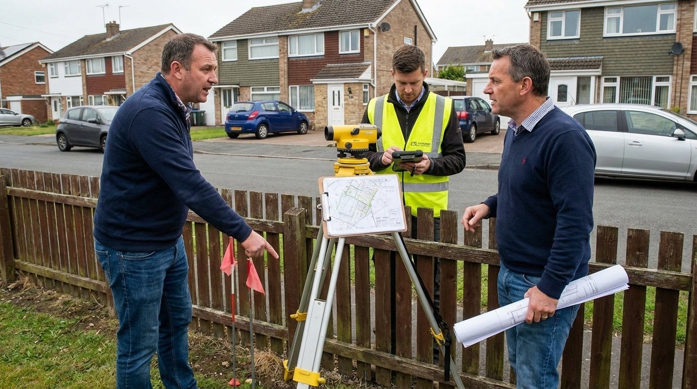
How Surveyors Establish Boundaries
Professional boundary surveys by chartered surveyors involve:
Documentary Research
Our team of London surveyors examines all available evidence:
- Title deeds: Original conveyance documents (often more detailed than Land Registry plans)
- Previous surveys: Historical boundary surveys if available
- Ordnance Survey records: Historical maps showing boundary features
- Planning applications: Submitted plans showing boundaries
- Aerial photographs: Historical images showing fence/wall positions
- Local authority records: Adoption of roads, sewers affecting boundaries
Site Measurements
Precise measurements of current physical features:
- Total station surveys: Accurate measurement equipment (+/- few millimeters)
- GPS surveys: For larger sites
- Measurement from known points: Road centers, building corners
- Level surveys: Height differences for retaining walls, slopes
Analysis and Interpretation
Combining evidence to establish most likely boundary:
- Reconciling documentary evidence with physical features
- Identifying discrepancies and their causes
- Applying legal principles where evidence ambiguous
- Providing professional opinion on boundary location
Report Preparation
Our expert surveyors produce detailed reports including:
- Scaled plan showing likely boundary position
- Summary of evidence reviewed
- Explanation of interpretation and reasoning
- Photographs of site
- Conclusions and recommendations
Cost: Boundary surveys typically £1,500-£4,000 depending on complexity and amount of research required.
Preventing Boundary Disputes
Prevention is far better than resolution. Our RICS surveyors recommend:
Before Buying Property
- Review title plans carefully: Check boundaries match physical features
- Walk boundaries: Physically inspect all boundary features during viewing
- Question sellers: Ask about boundary disputes or uncertainty
- Check for encroachment: Do neighbors' structures cross likely boundaries?
- Commission boundary survey: If any uncertainty, get professional survey
- Speak with neighbors: Understanding neighbors' views prevents surprises
After Purchase
- Don't alter boundaries immediately: Wait to understand existing arrangements
- Discuss before changes: Speak with neighbors before fence/wall work
- Keep evidence: Photograph boundaries when you move in
- Maintain properly: Regular maintenance reduces encroachment risk
- Document agreements: Written confirmation of boundary agreements
- Address issues early: Don't let problems fester
If Planning Building Work
- Check boundary location: Before designing extensions
- Stay within your land: Even encroaching 10cm causes problems
- Party Wall Act: Comply if working on/near boundaries
- Inform neighbors: Early communication prevents disputes
Resolving Boundary Disputes
If disputes arise, our chartered building surveyors recommend this approach:
Step 1: Communication
Most disputes resolve through calm discussion:
- Approach neighbor politely and non-confrontationally
- Show your evidence (title plans, deeds)
- Listen to their perspective
- Look for compromise solutions
- Consider professional mediation if communication difficult
Many boundary disputes stem from misunderstanding rather than dishonesty. Our experience shows 60-70% of disputes resolve at this stage with good communication.
Step 2: Joint Surveyor Appointment
If discussion fails, jointly instruct surveyors:
- Both parties share cost of professional boundary survey
- Surveyor acts impartially, examining all evidence
- Professional opinion often accepted by both parties
- Far cheaper than each party getting separate surveys and legal advice
Our team of London surveyors regularly acts as joint appointees, providing impartial expert opinions that resolve disputes without court action.
Step 3: Boundary Agreement
Document agreed boundary position formally:
- Written agreement: Both parties sign document confirming boundary
- Plan attachment: Scaled plan showing agreed line
- Land Registry update: Can register boundary agreement
- Bind future owners: Agreement runs with land
Cost: Solicitor fees £500-£1,500 for preparing and registering agreement.
Step 4: Mediation
If agreement fails, consider mediation before litigation:
- Independent mediator: Helps parties find compromise
- Without prejudice: Discussions confidential
- Success rate: 70-80% of mediations reach settlement
- Cost: £1,000-£3,000 shared between parties (far less than court)
- Timeline: Can resolve in weeks rather than years
Step 5: Court Action (Last Resort)
Litigation should be absolutely last resort:
- Cost: £10,000-£50,000+ in legal fees (each party)
- Expert evidence: Surveyor expert witness fees £5,000-£15,000+
- Timeline: 1-3 years to final hearing
- Uncertainty: Judge's decision may please neither party
- Relationship damage: Permanently destroys neighbor relations
- Stress: Extremely stressful for years
Our expert surveyors have seen many boundary disputes reach court where £20,000+ legal costs are spent arguing over 0.5 meters of land worth £500. Court should truly be last resort when all other options exhausted.
Legal Principles in Boundary Disputes
Our RICS surveyors understand key legal principles affecting boundaries:
Presumption of Boundary Position
Where documentary evidence unclear, legal presumptions help:
- Hedge and ditch rule: If hedge on bank with ditch, boundary usually in far side of ditch
- Party walls: Boundary runs down middle of wall
- Highways: Boundary usually at edge of adopted highway
These are presumptions only—clear evidence overrides them.
Adverse Possession
Occupying someone else's land openly for sufficient time can transfer ownership:
- Registered land: 10 years occupation plus application process
- Unregistered land: 12 years occupation acquires ownership automatically
- Requirements: Occupation must be actual, exclusive, open, and without permission
Adverse possession is difficult to prove and rarely successful, but the possibility motivates addressing encroachment promptly.
Prescriptive Rights
- Rights of way: Can be acquired by 20 years use
- Light: 20 years uninterrupted light access creates rights
- Parking: May create rights over time
Special Boundary Situations
Basement Boundaries
Underground boundaries often undefined. Basement extensions must stay within property boundaries—even underground encroachment is trespass. Our chartered surveyors advise on basement boundary issues.
Airspace Boundaries
You own airspace above your property to "such height as is necessary for ordinary use and enjoyment" (practical height around 500-1000 feet). Overhanging structures (balconies, eaves) may trespass in airspace.
Rivers and Water Boundaries
If property borders river/stream, boundary typically runs to center line (unless tidal river or specific documentation states otherwise). Complex area requiring specialist advice.
Leasehold Boundaries
Leaseholders' boundaries defined by lease. Common issues with balconies, roof terraces, and shared areas. Our expert surveyors review leasehold boundaries carefully.
Boundary Dispute or Uncertainty?
Get professional advice from experienced RICS chartered surveyors before problems escalate
Contact Our Boundary Experts